Sunday, May 25, 2008

Riverfest Fireworks

Every Memorial Day weekend is Riverfest, the huge outdoor concert and fried-food-eating party held in both downtown Little Rock and North Little Rock. The fireworks display marks the end of the party.

I like this spot for fireworks pictures, they pop right around the downtown buildings. The downside is that the smaller fireworks are obscured by the buildings, so you do miss part of the show. Another downside is that this was taken right next to a cemetery, so it can be a bit creepy.

Riverfest Fireworks

Went to this same spot last year, but didn't get many good shots. Turns out I had accidentally left a polarizing filter on the camera. Made sure not to do that this time...

Wednesday, May 21, 2008

Full Moon and the Junction Bridge

Got an email from a contact on Flickr about shooting locations around Little Rock that would look cool with the full moon rising. I suggested the Big Dam Bridge and the Junction Bridge, and ended up meeting him out for a little photo trip. We went by the Big Dam Bridge first, but couldn't see the moon all that well. From there we moved over to the Junction Bridge, and tried to get a few shots. Luckily there were no crazy people encounters that night...

Here's a view of the bridge with the Little Rock skyline underneath.
Junction Bridge

The Junction Bridge is an old railroad bridge, built in 1885. When the bridge was built, most of "La Petite Roche," or the actual little rock from which the city took its name, was dynamited away for the bridge foundation. The bridge was abandoned in 1984, until the county decided to convert it to a pedestrian bridge. It had its grand opening last weekend.

And a shot of the bridge with the full moon and some clouds:
Full moon and the Junction Bridge

Tuesday, May 20, 2008

Haw Creek Falls

After Pam's Grotto, I had time to hit just one more waterfall before it started getting dark. These falls were just up the road, and didn't even require a hike to reach them. In fact, you can see them from the car. The falls are Haw Creek Falls, which aren't very tall but are still really neat. I've made many trips to this little set of falls over the years, especially while in college since they weren't that far of a drive. I even made it to these falls a few months ago.

There was a nice mist hanging over the creek...
Haw Creek Falls

The falls are only about six feet tall, but nearly stretch across the entire width of the creek...
Haw Creek Falls

I then decided to head on home, stopping in Russellville to get gas and work on the duct tape and garbage bags protecting the hole in my sunroof from the rain (it managed to keep out all the rain that day, but was defeated by the wind on the freeway). But in Russellville, the tornado sirens were going off. Turns out a nasty storm was brewing north of town that could be tornadic. I called a friend to ask kindly if he would turn on the weather so I could make sure I wasn't about to drive into a tornado. All of it was well to the north, so I was able to make it home instead of to Oz.

Sunday, May 18, 2008

Pam's Grotto

Leaving Longpool, there was a light rain falling. It was thundering off in the distance, and I wondered if I should continue on considering the weather. I decided to head off anyways to a nearby waterfall, not realizing that there were some nasty storms not that far off. Turns out that there might have been a tornado in the same area that I was, but I managed to get through the day just with some light rain. I only had to use an umbrella once, and that was probably more from water dropping down off of the trees.

The next waterfall that I hit was Pam's Grotto Falls. These falls are in the Ozark National Forest in Johnson County, northeast of Clarksville. I drove up and parked at the small parking area, which is next to Haw Creek. The parking area provides some nice access to the creek, where I got these shots:
Haw Creek

Haw Creek

The trail to Pam's Grotto starts off across the road from the parking area. I walked along and got this shot of a small waterfall on the creek that flows through Pam's Grotto.
Waterfall by Pam's Grotto

The hike to the waterfall is short (1 mile), but steep. Having hiked there last year, I was prepared for the steep climb, which reminds you just how out of shape you are. The trail was built for rock climbers, who like to scale some bluffs here. The trail heads up to the bluffs, and after switchbaking up the hill it levels out and follows along the bluffline. After you finally make it to the bluffs, the hike is nice and level. You then follow along a fairly level trail that allows you to admire the tall bluffs. But then it shoots downhill in a muddy and steep descent to the falls. I made my way down there, mostly by scooting down butt-first. This probably wasn't the most exciting way to get there, but it worked. Then I made my way around to the falls, but got startled by a large snake sitting out on some rocks in the middle of the path to the falls.

Snake!
The snake probably wasn't poisonous, but I didn't want to take any chances. Luckily it must have smelled me there (and having been hiking all day, I probably didn't smell like flowers). It then slithered off and went into the rocks. I kept my distance and avoided that area, just in case.

Pam's Grotto Falls were just a few feet away. They aren't that tall, just 37 feet, but are a very pretty waterfall all the same. The falls are flanked by huge boulders, which give the area a nice personality.
Pam's Grotto Falls

Pam's Grotto

A side view of the falls:
Pam's side

And a view from the front of the falls:
Pam's Grotto

And a view of the small waterfall formed by the creek, which was a hard shot to get. To reach this position meant scrambling across some slick rocks and setting up the camera and tripod in the narrow channel created by the creek. But I liked the moss and the green seeds (I think) from the oak trees that had fallen there.
Pam's Labyrinth

And another shot of the falls:
Pam's Grotto

Pam's Grotto

And another shot, along with the large boulder that guards the falls.
Pam's Grotto

It was starting to get late, so I decided to head back. The trail is much nicer heading downhill, and I was soon back at my car. I had just enough light left in the day to hit one more waterfall, which luckily was just up the road....

Tuesday, May 13, 2008

Big Piney Creek and Longpool Falls

Woke up Saturday to some good waterfall hunting weather. The only problem was, where to go? I opted to hit up a few waterfalls a bit closer to home, which I had already been to once in the past year.

The first waterfall was Longpool Falls, located next to Big Piney Creek in the Ozark National Forest north of Russellville. Before hitting the trail to the falls, I had a look around Big Piney Creek:
The way to Longpool

The creek was running high, and looked cold. There were a few people braving the stormy weather and floating by on kayaks.
Big Piney

Big Piney
The trail to Longpool Falls is short (1.5 miles), and except for some rocky footing around the falls, is an easy hike. The first part runs along a hill overlooking the creek, then drops down and runs up to this little waterfall.
Lower Longpool Falls

From there it's just a scramble over to Longpool Falls, which are about 40-50 feet away. I was pleased with myself for finally finding the "trail" that leads up the falls, I had managed to somehow miss that every other time I've been here. Instead I would find the most haphazard way to the falls, resulting in a few comic slips and falls. But I eventually made it, though there wasn't much water in the falls.
Longpool Falls

It was a bit different than the last time I was here, in January. The bluff was covered in icicles.
Longpool Falls
I walked around the base of the falls, and got this shot looking out from behind Longpool Falls.
Behind Longpool

After that it started getting really dark in the forest, and I kept hearing thunder off in the distance. I didn't know it at the time, but there were some pretty nasty storms not that far away. I got back to the car, in a light rain, headed off to the next waterfall...

Saturday, May 10, 2008

Another dam shot from the Big Dam Bridge

My car's "I need gas!" light had blinked on while driving to work today, so my drive home from work was spent trying to find a place to get cheap gas. I finally found the cheapest gas, at $3.53 a gallon, which sucks since that is considered "cheap" now. After spending half my paycheck on gas, I noticed that there were some interesting clouds floating around, which might turn into a neat sunset. So I went home, got the camera, and went to the Big Dam Bridge.

The sky was filled with lots of low cumulus clouds (I think that's what they are?), and I thought that the sun might hit those clouds and light them up and make a good shot. That didn't quite turn out, but I did get this shot of the sun breaking through the clouds over the river...
Another dam shot from the Big Dam Bridge

Friday, May 9, 2008

A few quick shots from the Big Dam Bridge

I've been having some minor problems with my car, which kept me at home last weekend instead of hitting the road to take some pictures. The problem, you ask? The glass in the sunroof on my car decided to shatter for some wacky reason, so I've been driving around with a garbage bag taped to the top of my car while waiting for the insurance company to get back to me. It's been nearly two weeks now, and hopefully I will get a check from my insurance company soon so I can get it fixed (State Farm sucks).

Since I didn't get to make a road trip to the Ozarks, I felt a bit restless not getting to take the camera out. So Sunday night I visited the Big Dam Bridge, the pedestrian bridge over the Arkansas River that is just a few miles from my apartment. I got there in time to catch the sunset, and eagerly awaited any cool light to hit the sky.

I sat on the bridge, looking to the west, and not much color appeared in the sky. The Big Dam Bridge is probably one of the best places in the state to catch a sunset, and I've been a bit spoiled since I saw one of the most amazing sunsets there last year. Here's a shot of it:
Stormy Sunset

Not really seeing much I headed over the river to the Little Rock side of the bridge. I rarely visit this part of the bridge, and wanted to take some photos from a different angle. I made it to the other side of the bridge, and saw that there was a sunset developing off to the west. Since I was already off the bridge, I didn't feel like going back up there, so I continued on and got this shot of the sunset from under the bridge.
Sunset from under the Big Dam Bridge

From there I walked along the River Trail, looking back at the bridge for any good views of the bridge. I found this shot of the bridge, with a large tree framing it against the river.
Big Dam Bridge and Big Dam Tree

Wednesday, May 7, 2008

Having a grape time in Altus

After heading to the top of Mount Magazine, there was one last place I wanted to check out before heading home. I drove by these fields filled with some wildflowers (or weeds?) along the side of the road.
Flowery fields

Easy to see why the flowers were thriving, seems like they've gotten lots of natural fertilizer...
Cows

My next stop was the town of Altus, Arkansas. Altus is probably one of the coolest small towns in Arkansas. You might remember Altus as being the location where Nicole Richie and Paris Hilton embarrassed themselves in the first season of "The Simple Life" a few years back. Going to college just twenty miles away, we used to make many trips to Altus, for several reasons:

1) Food. For being a small town (population 817), there are some great places to eat. The Swiss Family Bistro at Wiederkehr Village is a must. And I'm craving the chicken béarnaise from Kelts right now.
2). Wine. Altus is home to four wineries, including Wiederkehr, which was founded in 1880.
3). Liquor. I went to college in a dry county, so we made a few trips out here for some other types of liquid refreshments. And now Altus is one of only two cities in the state that sells alcohol on Sunday (Eureka Springs being the other).

This was taken along the side of the road north of Wiederkehr Village.

Looking back, I probably should have taken the price tag off before taking the picture.
Before & After

Another cool thing about Altus is the really neat old Catholic Church. St. Mary's Catholic Church, built in 1902, is filled with lots of neat murals and stained-glass windows. It was late afternoon and the light was pouring into the church.
St. Mary's Catholic Church

And a shot of some of the stained-glass windows:
St Mary's

And a shot of the outside of the church, which sits on a hill with a commanding view of the valley and Altus below.
St. Mary's Catholic Church

My plan was to get a shot of the church lit up at night, and I sat out there for awhile waiting for it to get dark. It was actually a bit cold up on the hilltop, and it seemed like the church really wasn't lit up all that much. There was a spotlight that shined on the steeple, but the rest looked like it was dark. Tired of sitting alone in the parking lot, I gave up and headed on. At least I got some wine out of it...

Sunday, May 4, 2008

Cherokee Prairie and Mount Magazine

I headed out to western Arkansas last weekend, to do some family stuff. I was in the town of Charleston, and on Sunday decided to take the scenic drive back home. My first stop was a prairie area just a few miles north of town. The Cherokee Prairie Natural Area is the largest tract of tallgrass prairie land in the state, at 566 acres. There you can find all sorts of wildflowers in bloom, and even a few prairie mounds there.
Cherokee Prairie
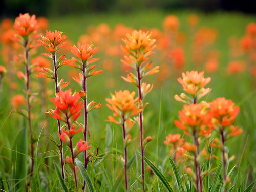
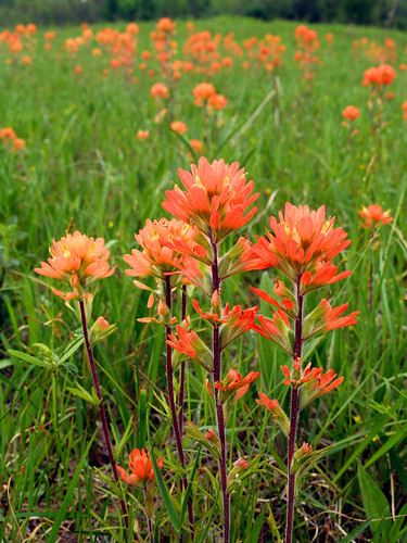
These flowers are called "Indian Paintbrushes," and were all over the prairie.
Cherokee Prairie
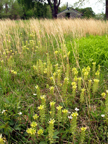
There is another prairie area nearby, just a few miles to the east. Called the Flanagan Prairie Natural Area, it was filled with the same type of flowers. Since it looked the same I won't bother with posting another shot of the same type of flowers. But driving back from Flanagan Prairie I did stop to get this shot of some other type of flowers growing near an old building.
Hwy. 60
I decided to take Hwy. 217 south from Charleston, which runs alongside Lake Charleston for a bit. The lake provides some neat views of Tater Hill, a small mountain that sits in Fort Chaffee. I had gotten a shot of Tater Hill once with the lake in the foreground, and looked to do a newer version of it. But it seems as if all the turn-offs to the lake were closed off, so no luck there. Following the road south, I saw this old barn and stopped to get a shot.
Old barn
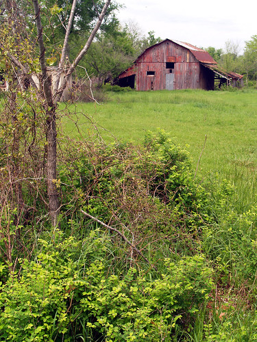
The barn's days might be numbered though. There was a sign there advertising this area for a future housing development, which will probably result in this barn being torn down. A shame, really.

From there I continued on to the east, with Mount Magazine as my next destination.

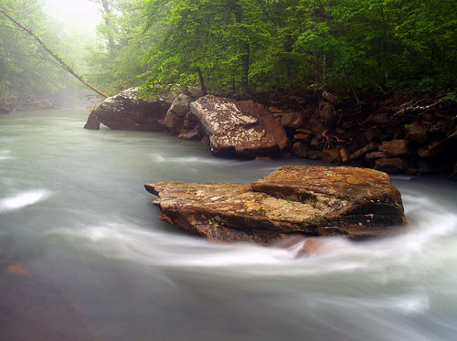
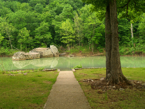
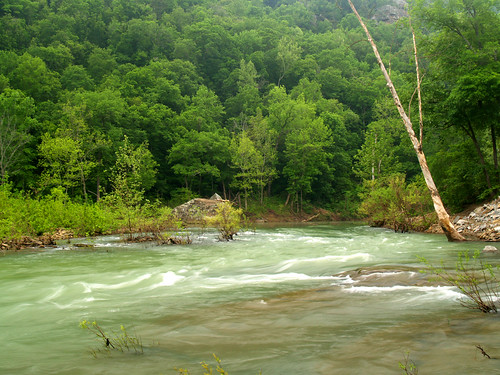
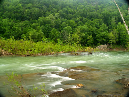
The first stop on the way there was Cove Lake, in the National Forest at the foot of the mountain. There is a trail that runs along the edge of the lake and I got out and went to explore it a bit.
Cove Lake
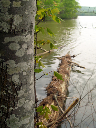
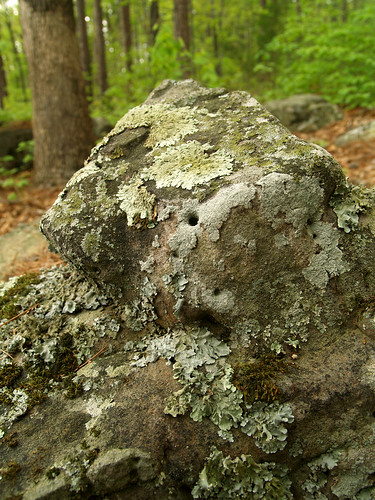
I didn't stay out there too long, turning back when I got a shot of the lake that I liked. I stopped to take a shot of this lichen-covered rock, which might have been a mistake since I had to stumble through a lot of poison oak to get to it.
Rocky
From there I headed uphill and went to the top of Mount Magazine, the highest point in the state at 2,753 feet. Arkansas has the 34th highest state point in the country. If you're curious about it (I was since I just looked this up), the state with the highest point is, of course, Alaska with Mt. McKinley (20,320 feet). The state with the lowest high-point is Florida (Britton Hill at 345 feet).

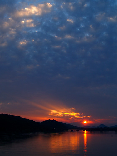
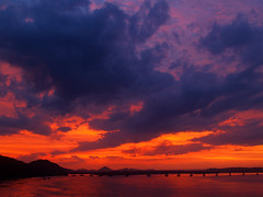
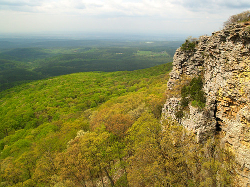
Mount Magazine isn't among the biggest mountains, but it does have some nice views. There is a road that visits a few overlooks (the road is helpfully named Overlook Road, in case you get confused). This was taken from one of the overlooks, looking down into the Arkansas River Valley.
Mount Magazine
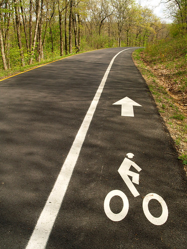
The road also accommodates bike riders, with this little bike path. I didn't see anyone out there riding, though it would have been a good day for it. Good thing there weren't any bike riders out that day since I was blocking the path taking this shot:
I want to ride my bicycle
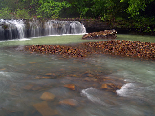
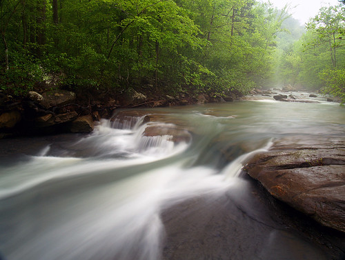
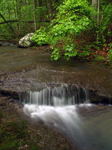
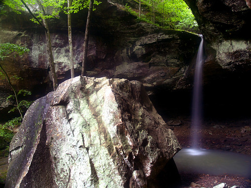
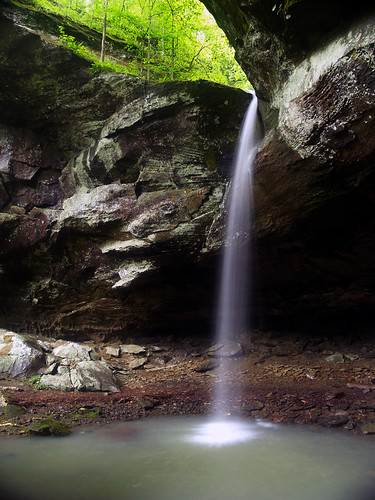
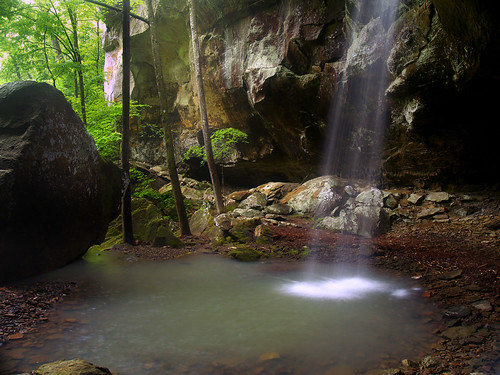
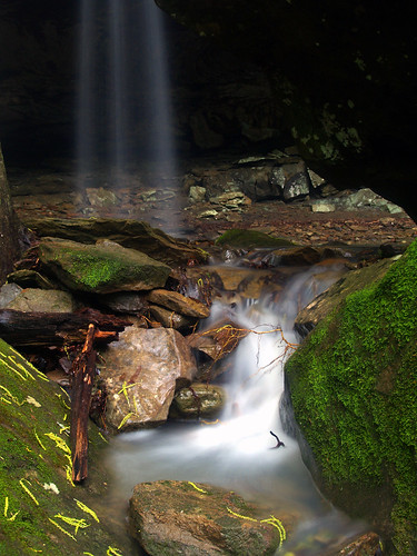
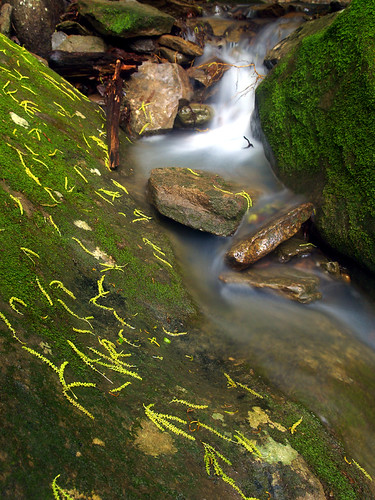
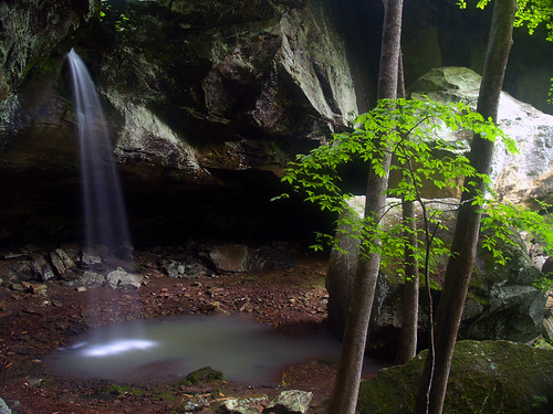
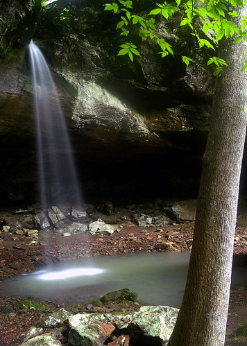
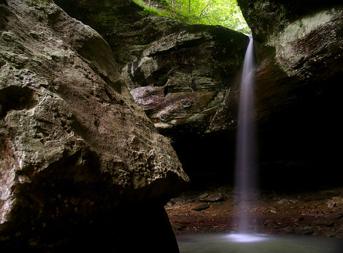
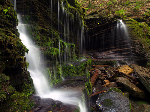
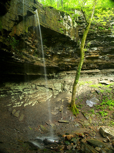
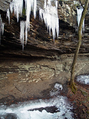
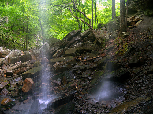
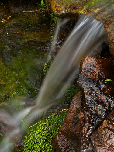
From there I went to find the Mount Magazine Cascade, a 100 foot cascade that tumbles down the side of the mountain. Since there hasn't been all that much rain here lately, I didn't think it would have much water in it. But the cascade is fed partly by spring water, so I thought it might be worth checking out. The cascade is along a short half-mile trail, which runs right to the top of the cascade. There really wasn't much water there after all, but I got this shot of a small waterfall along part of the cascade.
Mount Magazine Cascade
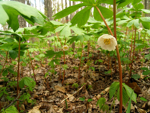
After visiting the cascade I went back and did the short hike to the summit of Mount Magazine, which would take me to the top of the state. The hike up there is easy. It is all uphill but it isn't very steep. Along the way there were lots of mayapples in bloom.
Mayapples
And then I made it to the top. The highest point in Arkansas is a bit anti-climatic. There isn't any grand sweeping view of the scenery up there, just a view of trees. They do have a rock outline of the state there, and a sign, so you do know you made it to the top.
Top of Arkansas
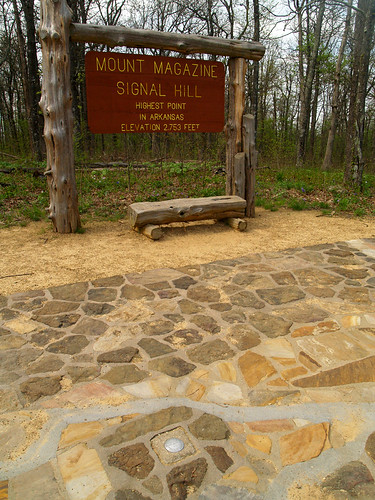
There weren't any other hikers out on the trail, so I had a few fun minutes of being the highest person in the state. Wait, that doesn't sound right. OK, I was the highest person up in terms of elevation. Which was pretty exciting, I guess.